Hydrological Cycle
Human physical factors determine the speed at which precipitation reaches the river. The amount of rainwater taken will affect how quickly the river fills up and its chance of flooding.
DRAINAGE BASIN HYDROLOGICAL CYCLE
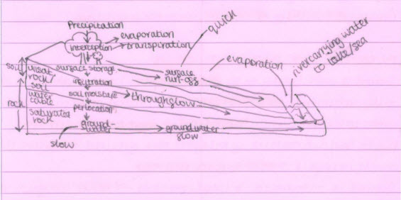
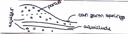
Infiltration: Water sinking into soil/rock from the ground surface.
Percolation: Water seeps deeper below the surface before reaching above.
Soil moisture: Water held in the soil layer.
Groundwater: Water held in the rock.
Throughflow: The water passing through the soil layers parallel to the surface and into the atmosphere.
Water table: The point at which saturated rock or soil can no longer absorb water.
Surface Runoff: The water going on top of the ground really quick.
Physical Factors
Climate
FLOOD RISK SITUATIONS
The ground is more likely to be impenetrable and hard - Ground is frozen/fully saturated.
Consistent rainfall - Ground never fully recovers, and the water table is constantly "topped off" - More surface runoff.
Due to the sudden nature of rainfall, the ground struggles to infiltrate much rainfall - Causes more surface runoff.
Ground is saturated - impermeable - more surface run-off - quicker flooding.
The ground is impermeable and frozen - when the snow melts, there’s lot of surface runoff - flooding.
GEOLOGY
Mountains in the UK typically contain slate. Slate is impermeable but has poor soils and little vegetation to intercept the rain.
Flooding is less likely in areas of permeable rock-chalk and limestone.
Low-lying valleys can often contain saturated clay soil, it’s usually vegetated, but the soil is so compacted, it’s sometimes hard for infiltration to occur.
When heavy rain falls, an impermeable surface generates a significant amount of surface runoff. Due to a lack of infiltration, water gets into the channel quickly, and the river channel, with increased discharge, bursts its banks and floods.
SLOP PROCESSES AND RELIEF
SLOP PROCESSES
Mass Movement
Definition: The downstream movement of rock/mud under the influence of gravity. The extent of movement is dependent on the steepness of the slope and the amount of water transported as rocks and sediments move.
Soil Creep: (Most common) Individual particles of soil move slowly down slope under the force of gravity and collect at the bottom of valley sides.
Slumping Landslide: (Less common, more rapid when it occurs) When the underlying rock is impermeable, landslides occur along linear slide planes, similar to rock bedding planes. The river erodes the valley side's bottom, resulting in slumping. The slope becomes steeper, and the material above rotates and slides downwards.
Periods of heavy rain often trigger movement, saturating the overlying rock and making it easier to slide.
HOW DOES CLIMATE GEOLOGY + SLOPE PROCESSES AFFECT
Geology: Drainage basin geology affects river landforms.
Slope Processes: Altitude can affect how much weathering/erosion a river can experience.
Climate: More rainfall = More erosion = More sediment load.
Geology: Depending on the type of rock, erosion can occur, adding to the river.
Slope processes: When a scree merges with a river load, the load increases.
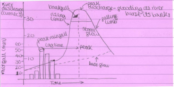
Storm Hydrographs
Factor affecting hydrographs: |
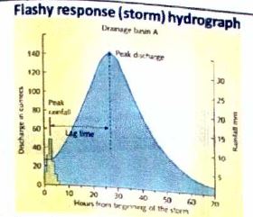
Flashy response (storm) hydrograph |
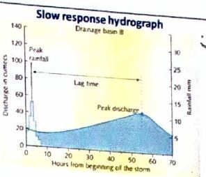
Slow Response Hydrographs |
|---|---|---|
Sudden flooding, also known as flash floods, is associated with a flashy hydrograph. The steep rising limb is a result of rainfall occurring under conditions that have caused a significant amount of surface runoff. The short lag time allows water to enter the channel quickly, resulting in a high peak discharge that puts the river at risk of flooding. |
An identical rainfall event on a slow response hydrograph will result in a less steep rising limb; the peak discharge will be lower, and the lag time will be longer, allowing the river time to remove the preceding water. On this type of hydrograph, the flood risk is low. |
|
| Precipitation | Large amounts of rainfall, often in winter; sudden snowmelt; heavy rainstorms in the summer when the ground is dry; continuous heavy rainfall for a long period of time. | Significant rainfall occurs throughout the year, but not all at once. |
| Geology | Impermeable rocks, such as slate, contribute significantly to surface runoff and a rapidly rising limb. This phenomenon results in a short lag time and increased peak discharge due to reduced infiltration. | Permeable rocks, like sandstone, have the capacity to absorb large amounts of water, facilitating infiltration and percolation, thereby prolonging the water's journey to the river. |
| Drainage basin size and shape |  |
A rounded drainage basin has a more circular than elongated shape; the water reaches the main channel more slowly as some water has further to travel. |
| Soil water storage capacity | Frozen soil and soil saturated by previous rainfall hold little water; clay soils have smaller pore spaces, so less water infiltrates and more runs off. | Unsaturated soil has the ability to store a significant amount of water, allowing for increased infiltration and reduced runoff. Sand soil is porous. |
| Slopes and soil depth | Steep slopes and shallow soils result in a significant amount of surface runoff due to the limited time and space for infiltration. | Gentle slopes and deep soils allow for slower surface runoff as there is more time and space for the water to infiltrate. |
| Vegetation | Little vegetation or less dense rainforest leads to less infiltration and more surface runoff and slows down lag time. | Woodland intercepts rainfall, and tree roots encourage water to infiltrate into the soil; afforestation helps reduce the flood risk. |
| Antecedent Conditions | When there has been lots of recent rainfall, the ground can't absorb much more water, so more surface runoff occurs (saturated soil). | When there has been little recent rainfall, the ground can absorb and store more water, so there is less surface runoff. |
| Towns and cities | Many urban surfaces, such as roads and roofs, are impermeable, so water quickly runs off into drains and rivers. | Less urbanised areas with less impermeable surfaces—less surface runoff. |
Enquiry question: Why is there a variety of river landscapes in the UK, and what are the processes that shape them?
4.7 River landscapes are influenced by human activity interacting with physical processes:
Natural factors can impact a hydrograph’s shape and lag time as seen in the previous section. Human activity also influences the hydrograph shape and lag time. In the UK, urban land use is the main cause of increased flood risk. This is due to the urban sprawl associated with urbanisation.
| Human factor | How it affects the drainage basin | How it impacts storm hydrographs |
|---|---|---|
 Urbanisation: When humans replace woodland or grassland in the drainage basin with buildings and roads, the impermeable surfaces. Drains and gutters in settlements channel water to rivers more quickly than natural processes. Urbanisation: When humans replace woodland or grassland in the drainage basin with buildings and roads, the impermeable surfaces. Drains and gutters in settlements channel water to rivers more quickly than natural processes. |
Creates more impermeable surfaces. Concrete expedites the process of allowing water to reach the river. Many buildings, roads, and car parks have impermeable surfaces, which increase surface runoff. The water enters the channel quicker than other pervious surfaces. |
Steepens the rising limb. This reduces lag times by increasing surface run-off. Increases the peak discharge. |
| Land-use change: Replacing woodland or fields with buildings or roads, or pasture with arable crops, increases runoff. Leaving arable (crop) fields bare in the winter, rather than permanently covered with vegetation, increases the likelihood of soils becoming saturated. | - More impermeable surfaces increase the surface runoff. - Soils can become saturated much more quickly. - Lack of vegetation and lack of interception. |
It steepens the rising limb. More surface runoff shortens lag times. It increases the peak discharge. |
| Deforestation: Felling trees can have a considerable impact, as dense forest uses up to 40% of any precipitation. This also exposes the soil that is washed into rivers. Enhancing the riverbed decreases the capacity of a river to retain water. Planting trees (afforestation) in the drainage basin has the opposite effect to deforestation and can help reduce the risk of flooding. | Loss of vegetation; soil is not held in place by the roots of the trees, and so soil can be washed into the river (soil erosion). Additionally, rivers are silting up due to an increased sediment load. Channel shape alters. River impacts capacity, so less water can be stored. |
Steepens the rising limb. More surface run-off shortens lag times. Increases peak discharge. It also impacts where the bank will discharge/flood. This will alter the hydrograph. The hydrograph will drop significantly below the chart. |
Flooding of the River Severn has been caused by the interaction of physical and human processes:
| Physical causes | Antecedent conditions (rainfall): Conditions in the drainage basin in the period before the rainfall event, such as saturated or frozen ground and the amount of rainfall that has fallen. The summer of 2007 saw high rainfall in the UK, resulting in widespread flooding. In July 2007, there was a period of heavy rainfall. In one year, England covered saturated ground, as rainfall was 2 and 1/2 times greater than normal. There was lots of surface runoff and less infiltration. On July 20, 140 millimeters fell in a few hours. |
| Physical causes | Jet Stream: A fast moving air current in the upper atmosphere. The jet stream does not remain stationary. Their location can affect the weather—and how fast an aeroplane can fly! The jet stream shifts its location, moving north during warm weather and south during cold. A shift in the jet stream's position led to periods of more persistent wet weather. The jet stream, though, for Europe, was in a trough located close to the UK and resulted in more unstable, wet conditions for a longer period of time. This resulted in a prolonged period of heavy rainfall, which in turn led to saturated ground and increased surface runoff. This meant more water entering the rivers and increased river levels. |
| Physical causes | Heavy rainfall: In June and July, the UK experienced rain, resulting in saturated ground that was unable to absorb any more water. Long rainfall raised the water table six weeks later, leaving the soil fully saturated and unable to absorb any more water, leading to an increase in surface runoff. This implies that the water table's rise led to an increase in base flow. The amount of rain that fell resulted in a dangerous rise in river levels. The river levels were extremely high, resulting in a significantly elevated base table level. |
| Physical causes | Changing land use: Deforestation in the upper course of the river Severn’s floodplain due to increased demand for timber, grazing land for sheep, and expansion of settlements such as Llandiloes has reduced the number of trees in the upper reaches of the drainage basin. This has reduced interception, increased the likelihood of soil erosion, and increased surface run off. |
| Physical causes | Changing land use: Urbanisation has increased the number of impermeable surfaces in the drainage basin. Settlements such as Shrewsbury and Tewkesbury have been built on the floodplain, right next to the river. As these settlements expand and the number of green spaces within them reduces the amount of infiltration can occur dramatically, silts, impermeable surfaces, and direct run off increases. In addition, the gutters and drains building channel water into the river more quickly than natural processes, adding to the increased incidence of flooding around these settlements. |
How do physical and human processes interact to cause flooding on the River Severn?
- When there is a significant amount of rainfall, the soil or aquifer becomes saturated and cannot hold any more water. This leads to increased surface runoff, which quickly fills up the water, resulting in less water being stored.
- When there is deforestation, there are fewer trees to intercept the rain, so the water gets to the river quicker.
- Urbanisation: Leads to an increase in impermeable surfaces and surface runoff, which in turn accelerates the flow of water into rivers.